- On sale
.
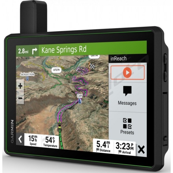
Navigation Garmin TREAD® SXS Powersport Edition
Product code: 227755
Roam the unknown - head off-road with this rugged powersport navigator and have an unforgettable time with your friends. It includes all the maps you need to stay on the right path, and offers the communication technology you need to stay connected on the go.
Features:
- use the Group Track feature for up to 20 riders, as well as position sharing to keep all riders together
- navigate with OpenStreetMap (OSM) on unpaved roads and trails using turn-by-turn trail navigation including Adventure Roads and audio announcements
- this rugged navigator is IP67 weatherproof and features an 8" glove-friendly touch screen
- download BirdsEye satellite imagery directly to the Tread without a computer
- use the Tread® app on your compatible smartphone and take advantage of Group Ride Mobile features for easy route planning and more
- integrated features offer more peace of mind. With an active subscription, you can use inReach® technology for global satellite communications
Specifications:
General:
- Dimensions (WxHxD): 20.7 x 16.9 x 3.1 cm (8.1 x 6.7 x 1.2")
- Display size (WxH): 17.2 x 10.8 cm (6.8 x 4.2"), 20.3 cm diagonal
- Display resolution (BXH): 1,280 x 800 pixels
- Display type: multi-touch glass display, HD TFT color display with enormous brightness and white backlight, display with selectable orientation
- Weight: 246 g
- Battery: Lithium-ion battery
- Battery life: up to 6 hours (with backlight at 50%) / up to 1 hour with backlight at 100%
- Water resistance: IPX7
- Drop test rating: MIL-STD-810
- Dust resistance: IP6X
- Magnetic mount: mount with magnetic lock
- Pipe mount (3.81 - 6 cm / 1.5 - 2.375")
- 1.5" ball adapter with AMPS plate: yes
Maps and memory:
- pre-installed cards: yes
- Data cards: microSD™ card (not included)
- 3D terrain: yes
- internal memory: 64 GB
- Possibility to add maps: yes
- Storage and performance capacity: microSD™ card with a maximum of 256 GB.
- map updates included: yes
- downloadable satellite images: yes (BirdsEye)
Sensors:
- GPS: yes
- Galileo: yes
- multi-GNSS positioning with 10 Hz: yes
- barometric altimeter: yes
- compass: yes
Outdoor recreation functions:
- point-to-point navigation: yes
- preloaded topographic maps: yes
- track navigation: yes
- trail navigation with turn-by-turn directions: yes
Navigation features:
- Garmin Real Directions™ route guidance: yes
- Tripadvisor® ratings for points of interest: yes
- Route customization by preferred cities/streets: yes
- Traffic data updates: yes (with Garmin Tread app)
- Intersection view with traffic signs: yes
- Speed limits (shows maximum allowed speed for most roads): yes
- Information on sharp turns, schools, red light cameras, speed cameras and more: yes
Advanced features:
- Smart notification via the Garmin app: yes
- Map and software updates via wifi: yes
- Access to live services via the app: yes
Motorcycle features:
- Glove-operable touchscreen: yes
- Functions for using music and media from smartphone or MP3 player: yes
- Sunlight readable and weather resistant: yes
- Garmin Adventurous Routing™: yes
- Motorcycle POIs (Points Of Interest) for motorcycle repair shops, dealers and more: yes
- Elevation profile: yes
- Round trip routing: yes
- service history log: yes
- supports custom maps: yes
- supports TOPO maps: yes
Camping functions:
- special routing according to the size and weight of the vehicle: yes
- directory of campsites and facilities: yes
- elevation information for roads: yes
- speed limit changes: yes
- user-friendly route planner with GPX file targets: yes
Overlanding functions:
- Integrated Inreach® technology (active subscription required; subject to regulation or prohibition in some jurisdictions): yes
- pairing with Garmin Powerswitch: yes
- compatible with Group Ride Tracker: yes (included)
- compatible with external GPS antenna with mount: yes
- compatible with external Inreach® satellite antenna: yes
- Group Ride Mobile: yes (with Garmin Tread app)
- track recording (track): yes
- IOverlander™ POIs (Points Of Interest): yes
- Displays for longitudinal and lateral slope: yes
- BirdsEye satellite imagery (download via wifi): yes
Group Ride Radio:
- Radio frequency band: VHF 169.4125/169.4250/169.4375/169.4500/169.4625 MHz
- Group Ride range: up to 13 km (8 miles) with antenna mounting kit
- Group Ride Tracking: up to 20 riders simultaneously
- Group Ride update rate: 5 seconds
- Radio transmitted recorded messages: yes
Outdoor Application:
- Dog tracking: yes (when paired with a compatible dog tracking system)
Contents:
- 1 x Garmin Nacigation device
- 1 x Garmin Group Ride Tracker
- 1 x Garmin VHF antenna
- 1 x cradle with magnetic lock
- 1 x power cable
- 1 x USB-C cable
- incl. antenna mounting kit
- incl. tube mounting kit

Garmin Ltd. is a leader in Global Positioning System (GPS) navigation products. Once found mostly in specialized equipment for aircraft and boats, GPS technology has been adapted for use in a variety of handheld and wristwatch units for users such as hikers, athletes, sportsmen, and automobile drivers. Garmin has sold five million units in its first dozen years. Its product line has proliferated into 50 different items marketed through a network of 2,500 dealers, distributors, and partners in 100 countries around the world. While the parent company is registered in the Cayman Islands, Garmin has manufacturing and sales operations in the United States (Kansas) and Taiwan and a marketing office in the United Kingdom.


